Fieldtrip Data Collection Report for Cameroon: Ecological Mechanisms Moulding Landscape Formations: A Remote Sensing and GIS Applications: – “Case Study in Cameroon“
Hangula Simon
Senior Conservation Scientist, Ministry of Environment forestry and Tourism, GRN
Dispatch Period: 14th February 2025−4th March 2025
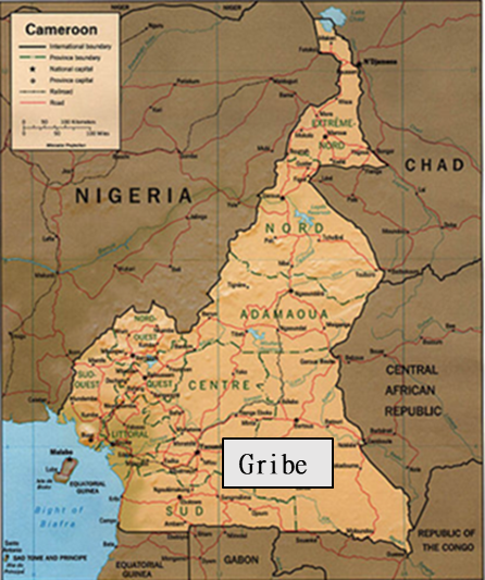
Destination of Dispatch: Tropical Rainforest Area, Southeast Province, Cameroon
1. Introduction
Friday, February 14th to March 4th, 2025, I, Mr. Simon Hangula, and my colleague Dr. William Kamgaing joining Dr. Koji Hayashi in Yaoundé Cameroon, undertook a field trip to carry out information-gathering on the socioeconomic status of the Bantu and Baka Pygmies in and around Gribe located in the forest region of the Eastern Region. The Country is situated in Central Africa, and parades a miscellaneous range of landscapes, including coastal, plains, rainforests, mountain ranges, and savannas known as “Africa in miniature”.
“Source: https://en.wikipedia.org/wiki/Geography_of_Cameroon
Changeable landscapes, come as a consequence of variable ecological mechanisms/processes such as wearing, debris deposits, plate tectonic, and climatic factors. From this perspective of the application of remote sensing (RS) and Geographic Information System (GIS) technologies, it is a clear testimony of the understanding, visualization, and insights into the ecological mechanisms that shape these landscapes. Human-socio-economic and geophysical processes, and environmental geography, are the synergies that, have taken up centre stage in the scientific research platforms recently in landscaping fragmentation/ formation. Many Ecological mechanisms are causing landscape dynamics, however, in this case study, the researcher investigates land disturbance, land productivity and land competition, and climate changes. The macro activities in ecological mechanisms that cause or drive landscape dynamics (patterns) are vital for the risk assessment for the many landscape dynamics/patterns observed in communal land. Land degradation, poor productivism/yield, deforestation, and land conservation are some parameters to be assessed in this research visit.
Sustainability is guided by the human ability/knowledge skill learned through educational methods of training; however, Indigenous Knowledge of land utilization and landscape fragments management is another fundamental aspect of the livelihood of the targeted communities. Disturbances on the other hand, in terms of natural forests its causing land degradation is one of the most interesting aspects of this research and is more directly linked with climate change.
Land Productivity and Land Competition, in general, are some of the ecological mechanisms contributing to the landscape dynamics of today’s world. To benefit from an inclusive approach, an informal interaction with the residents of the study area was conducted. Mr. Simon, with the help of the local people, identified and mapped out the significant land use marks and ecological landscape fragments forms in the area.
Data collection and verification for this research involved virtual and laboratory (Remote sensing and Geographical Information System analyses and interpretation) and fieldwork methodology (ground truthing of the unique and heavy land use change, questionnaire interviews). The data from the questionnaire will be entered into the GIS spreadsheet (attribute table) and exported to an Excel sheet for statistical analysis.
2. The objective and aim of the study
To collect data that will enable us to map out and identify the ecological mechanisms, (land use, and land cover activities) as the enablers of landscape patches or forms in Gribe, eastern Cameroon, and the relationship between the education systems (informal, non-informal education, and formal education) productivity, the socio-economic profile of the Bantu and Baka (main livelihoods). Understanding the main agropastoral and main crops productivity per the community to determine the rough estimate of their productivity and land degradation, decline in biodiversity, natural hazards, etc.), their levels, their trends, and trajectory, To forensically audit and perception of the targeted community landscape change to verify the remote sensing data and GIS reconstruct the landscape ecology dynamic of the study areas based on the best earth observation data available from the late years to the recent years using remote sensing and geographical information systems. Finally, ground truthing sense is used to verify and estimate the forest cover change, land cover change, and the forest’s area covers lost over the years. The ultimate purpose is to compare and contrast the land-use patterns between Cameroon, and Southern Africa.
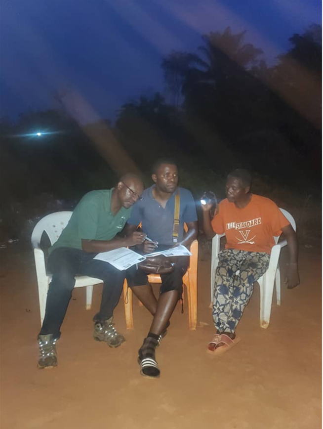
The approach for this fieldwork, the data collection involves local people (namely the Bantu and Baka) and the researchers from ASAFAS. Before the interviews and interaction with the communities, to compile the questionnaire, Dr. W. Kamgaing, one of the researchers from ASAFAS, helped me to tailor the content to the Cameroonian socioeconomic setting, with relation to the daily practice in terms of livelihood, substance farming school, and biodiversity alteration. From the gaps identified during the project research proposal, Dr. W. Kamgaing was lobbied in for the ultimate translation purposes from English to French directs /language from the onset of the project. In Gribe and the surrounding area of interest, more Bakas were in the forest for foraging and hunting purposes, therefore most of the interviews were carried out during the late hours of the day.
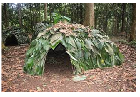
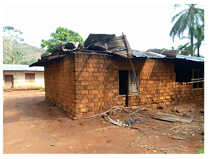
The first striking distinctive comparison practice between the Baka and the Bantu ethnic grouping is the shelter structure, and the in-depth part is their involvement in agropastoral practices. The Baka community especially women and children congregate and live in a grouping of families. The farming of the Baka families is very at lowest compared to the Bantu families. The number of farms owned by these groups differs in size and numbers and also the huts-shaped structures of the Baka are uniquely smaller compared to the Bantus.
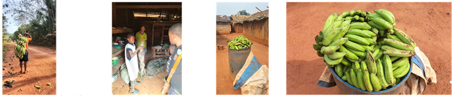
During the interviews in Gribe and Zokadiba, hunting in this part of the world involves men who prefer to answer hunting, utilizing traditional weapons and methods such as traps and poisoned arrows, targeting animals’ questions, and information provision. On the other hand, foraging is more associated with women and children, they provide accurate information on plant foods like wild tubers (a staple), plantain, bananas, leaves, mushrooms, and fruits. Although still relying heavily on foraging, a fair share of the Baka communities are gradually complementing their nourishment with agropastoral products from the settled immigrants. Throughout the interviews a questionnaire that was structured in such a way that it captured the records/data of the community such as age cohorts, personal identity, academic level, biodiversity degradation, deforestation, foraging- hunting, and Global Geographical Positioning (GPS) for the participants was used.
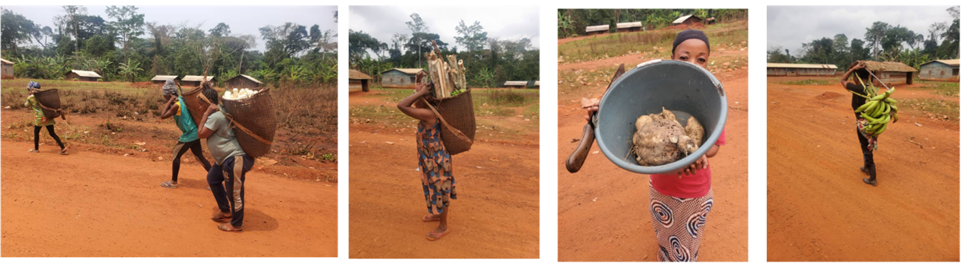
From the perspective of land degradation, desertification, and productivity, land clearing is extended by adding to the existing farm every year, this is archived by clearing and burning a new portion of the forest next to the farm. Farmland ownership in Cameroon is private, therefore land tenureship is managed by the household heads and ruled by the Traditional Authority. The socio-economics of these communities are said to be fuelled by Cocoa, bananas are mostly used to manufacture whiskey, and plantain and cassava were the staple food crops and were featured on almost every family farm. Largely, the most basic outcome advises that the community under study believed that the agropastoral practice and productivity are intact. However, timber and wood logging are the main issues for the locals and drastic steps are required to strengthen maintainable land disturbance ecological mechanisms and proper education toward land use sustainability.
3. Acknowledgment
I would like to express my gratitude to the people I have stated above, as well as to the organizations such as (Kyoto University, ASAFAS, Ministry of Environment Forestry and Tourism, Namibia, Japan Society for the Promotion of Science (JSPS RONPAKU, and Grant-in-Aid for Scientific Research (S) No. 22H04929) for their cooperation and opportunity to put together my data collection thank you once again to you all.